Environment & Ecology
Why Karnataka Rejected the Western Ghats ESA Draft: Gadgil vs Kasturirangan Explained
By Shivam Singh, Founder & Mentor, Minimalist IAS
· Updated · 6 min read
Karnataka has rejected the seventh draft notification declaring parts of the Western Ghats an Ecologically Sensitive Area (ESA), which would cover 20,668 sq km across 10 of its districts. Both Houses of the State Legislature unanimously demanded a year for a physical, village-by-village survey, arguing that boundaries drawn from 2012 satellite data sweep farms and settlements into the ESA.
In the news (27 September 2026): Both Houses of the Karnataka Legislature unanimously rejected the Centre’s seventh draft ESA notification of 27 July 2026, based on the Kasturirangan Committee report, and sought one year to conduct a survey-number-wise physical demarcation before any area is finalised.
Key facts at a glance
The draft: 27 July 2026 (the seventh since 2014); 56,825 sq km of ESA in six States — Gujarat, Maharashtra, Goa, Karnataka, Kerala and Tamil Nadu.
Karnataka’s share: 20,668 sq km in 10 districts — the largest of any State.
The resolution: moved by Forest Minister Ramalinga Reddy; unanimous in both Houses.
The demand: one year for a physical survey by a high-level committee headed by a retired judge, followed by talks with the Centre.
Legal basis: ESAs are notified under the Environment (Protection) Act, 1986; project clearances follow the EIA Notification, 2006.
Gadgil vs Kasturirangan: two committees, two scales
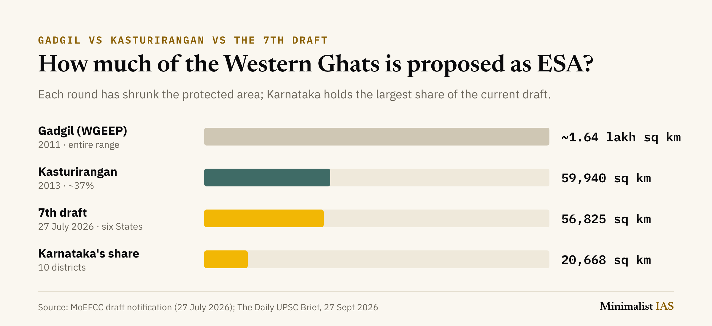
Gadgil Committee (WGEEP), 2011: the entire Western Ghats (~1.64 lakh sq km) as ecologically sensitive, in three zones of graded regulation; a precautionary, biodiversity-first approach with a role for Gram Sabhas.
Kasturirangan Committee (High-Level Working Group), 2013: only the “natural landscape” — about 37%, or roughly 59,940 sq km — as ESA; the rest (cultural landscape) left to normal regulation.
What governments adopted: the Kasturirangan model is the basis of every draft notification since 2014.
What would the ESA restrict?
Banned: mining, quarrying and sand mining; thermal power plants; red-category industries; buildings over 20,000 sq m.
Regulated, not banned: other development, through environmental clearance.
Allowed with conditions: repair and renovation of existing structures; hydropower projects only after a cumulative impact study and with at least 30% uninterrupted river flow in the lean season.
Why did Karnataka reject the draft?
Data: boundaries rely on 2012 satellite imagery without a joint physical survey; forest, revenue and farm land not accurately separated.
The 20% rule: an entire village falls in the ESA if just 20% of its area qualifies.
Pending land issues: forest rights claims, land grants and court cases must be settled before boundaries are fixed.
Livelihoods: plantation and farming communities in the Malnad and coastal districts fear restrictions; bipartisan political resistance.
Is there a middle path?
Kerala’s model: ground-truthing cut its ESA from 13,108 sq km to 9,993.7 sq km — cited by Karnataka’s legislators as the template.
Karnataka’s committee: retired judge, revenue officials, farmers’ representatives and environmental experts to demarcate survey number by survey number.
Risk of delay: seven drafts in 12 years; each lapse leaves the Ghats without final legal protection.
What is at stake?
Environmental: a UNESCO World Heritage Site (2012) and part of the Western Ghats–Sri Lanka biodiversity hotspot; source of the Godavari, Krishna and Kaveri systems.
Disaster risk: steep, rain-soaked slopes prone to landslides (Wayanad, Kerala, July 2024); experts link quarrying and land-use change to higher risk.
Federal: a shared ecological unit across six States vs State control over land and revenue records — a test of cooperative federalism.
Livelihoods: farmers and plantation workers vs a blanket village-level rule.
Way forward: a time-bound ground survey; plot-level rather than village-level demarcation; settle forest rights claims first; incentives for conservation (payments for ecosystem services).
Why it matters for UPSC
GS Paper 3 (conservation, environmental pollution and degradation, environmental impact assessment; disaster management) and GS Paper 1 (physical geography of India). For Prelims, the two committees, the ESA legal basis and the 20% village rule are testable; for Mains, the case is a ready example of the conservation-vs-livelihood trade-off and of federal friction over a shared ecosystem.
Mentor’s note
UPSC asked about these two reports in Prelims 2016; the next question is likelier to test the detail — which committee proposed the smaller area, under which Act ESAs are notified, and what the draft bans.
In a Mains answer, do not present Gadgil as “right” and Kasturirangan as “wrong”. Contrast the two approaches (precautionary vs accommodative), then argue for plot-level ground-truthing, as Kerala did — that is the balanced conclusion examiners reward.
Keep the three numbers distinct: Kasturirangan’s ~59,940 sq km, the draft’s 56,825 sq km, and Karnataka’s 20,668 sq km.
Practice: Prelims MCQ
With reference to the proposed Ecologically Sensitive Area (ESA) in the Western Ghats, consider the following statements:
ESAs are notified under the Environment (Protection) Act, 1986.
The Kasturirangan Committee proposed a smaller area as ecologically sensitive than the Gadgil Committee.
Under the draft notification, an entire village is included in the ESA only if at least half of its area qualifies.
Which of the statements given above is/are correct?
(a) 1 and 2 only
(b) 2 and 3 only
(c) 1 and 3 only
(d) 1, 2 and 3
Answer: (a) 1 and 2 only
Explanation: Statement 1 is correct — ESAs are notified under the Environment (Protection) Act, 1986. Statement 2 is correct — Kasturirangan proposed about 37% (~59,940 sq km) against Gadgil’s entire range (~1.64 lakh sq km). Statement 3 is incorrect — a whole village is included if just 20% of its area qualifies, which is Karnataka’s main objection.
Related PYQ — UPSC CSE Prelims 2016: “‘Gadgil Committee Report’ and ‘Kasturirangan Committee Report’, sometimes seen in the news, are related to
(a) constitutional reforms
(b) Ganga Action Plan
(c) linking of rivers
(d) protection of Western Ghats” — Answer: (d).
Practice: Mains question
Examine why the notification of the Ecologically Sensitive Area in the Western Ghats has remained unresolved for over a decade. Suggest a way forward that balances conservation with livelihoods. (Answer in 250 words) 15
Terms to know
ESA: Ecologically Sensitive Area
WGEEP: Western Ghats Ecology Expert Panel (the Gadgil Committee)
HLWG: High-Level Working Group (the Kasturirangan Committee)
EIA: Environmental Impact Assessment
MoEFCC: Ministry of Environment, Forest and Climate Change
Frequently asked questions
Why did Karnataka reject the Western Ghats ESA draft?
Karnataka says the ESA boundaries rely on 2012 satellite data without a physical survey, fail to separate forest from farm and revenue land, and include a whole village if just 20% of its area qualifies. Its legislature has sought a year for a village-by-village survey.
What is the difference between the Gadgil and Kasturirangan reports?
The 2011 Gadgil Committee proposed the entire Western Ghats, about 1.64 lakh sq km, as ecologically sensitive in three zones. The 2013 Kasturirangan Committee limited the ESA to the natural landscape — about 37%, or roughly 59,940 sq km.
How much area does the current Western Ghats ESA draft cover?
The seventh draft notification, issued on 27 July 2026, proposes 56,825 sq km as ESA across six States. Karnataka’s share, 20,668 sq km in 10 districts, is the largest.
What activities are banned in the Western Ghats ESA?
The draft bans mining, quarrying and sand mining, thermal power plants, red-category industries and buildings over 20,000 sq m. Other development is regulated through environmental clearance rather than banned.
Under which law is an Ecologically Sensitive Area notified?
Ecologically Sensitive Areas are notified by the Union government under the Environment (Protection) Act, 1986, and projects within them need clearance under the EIA Notification, 2006.
Key takeaways
Gadgil wanted the whole range protected; Kasturirangan cut it to about 37%; the 2026 draft proposes 56,825 sq km.
Karnataka, with the largest share (20,668 sq km), rejects the draft over satellite data and the 20% village rule.
Kerala’s ground-truthing shows the likely middle path: plot-level demarcation, not a blanket village rule.
Related reading
Odisha’s wettest monsoon since 2000 and the Bay of Bengal deep depression
Practise previous-year Environment questions in the free PYQ vault
Revise the NCERT basics of India’s physical geography in NCERT Foundations
Sources
Karnataka rejects latest Kasturirangan ESA draft, seeks one year for fresh survey — The Week
Why Western Ghats States can’t agree on Eco-Sensitive Areas — Mongabay India
From The Daily UPSC Brief, 27 September 2026 — by Shivam Singh.
Spotted an error or something outdated? Tell us — we correct it.
About the author
Shivam Singh
Founder & Mentor, Minimalist IAS
Shivam has been through every stage of the exam himself — Prelims, repeated Mains attempts across UPSC and state civil services, and the interview board. For 7 years he has mentored aspirants one-to-one, helping 100+ clear various stages of the exam, including final selections.
More about Shivam →